


Villa Vieja Revisited: Gibraltar’s True Origins May Lie Elsewhere


This is the second in a three part series written by Carl Viagas. The series will be published weekly on Mondays.
Following the wide interest in the Chronicle article of 23rd May 2025 on the Northern Defences, many readers raised questions about Gibraltar’s oldest urban area. Chief among them: Is the Villa Vieja—the area beneath the Moorish Castle—really the original core of Gibraltar’s settlement? This article addresses that question by examining historical records, maps, and the physical terrain itself.
The commonly held view is that the Villa Vieja, or “Old Town,” represents the earliest part of Gibraltar. Its name, the steep streets below the castle, and its walled enclosure have all contributed to the belief that it marks the location of the Islamic foundation of Gibraltar in
1160 by ʿAbd al-Muʾmin. Yet when examined closely, the evidence tells a different story— one in which the Villa Vieja may not have been the origin of the town, but a later, strategic expansion linking the castle to the urban areas further south.
A Name That Misleads
The name Villa Vieja is not of Islamic origin. It first appears in Christian-era sources following the Castilian capture of Gibraltar in 1462. In many Spanish towns retaken during the Reconquista, names like Villa Vieja were applied to earlier fortified zones, even when they were not the site of original settlement. This reflects a post-conquest perception rather than historical reality.
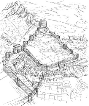
Geography: Too Steep to Settle
The Villa Vieja occupies just 10,000 square metres (1 hectare) on a steep slope between the Moorish Castle and what later became the Barcina and Main Street. This makes it poorly suited for urban development. There is no flat plaza, fresh water supply, no evidence of a mosque or early church, and no indication of civic or market space—features one would expect from an original Islamic medina or Christian town.
In contrast, Parliament House, John Macintosh Square and The Cathedral (within La Turba) sit on a more level spine of the Rock, with easier access, reasonable size, a more regular street pattern, and continuity of religious use. These factors suggest that the area surrounding the Cathedral of St. Mary the Crowned and John Macintosh Square may, in fact, represent the true urban nucleus of Gibraltar.
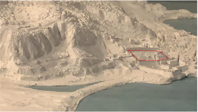
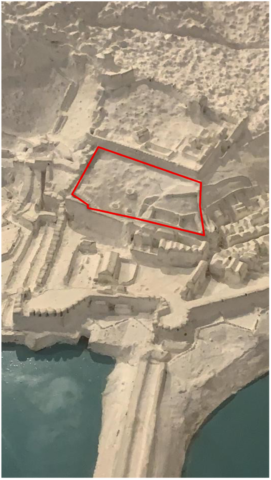
1781 Rock Model - Royal Engineers Museum in Chatham
(The Villa Vieja area appears as unpopulated but circular structures suggest possible lime kilns) The main populated area appears to the south.
What the Maps Show
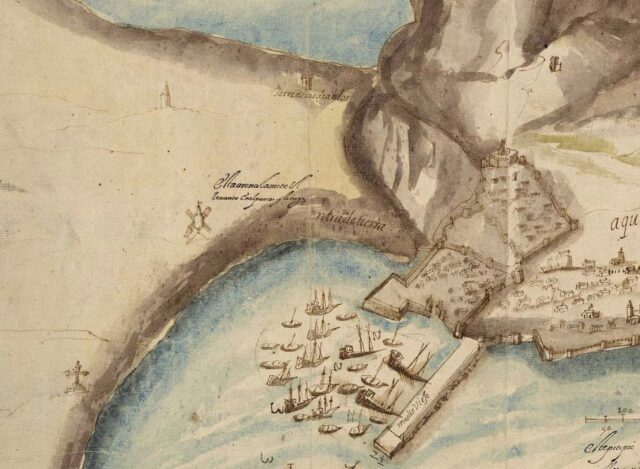
Several early maps support this interpretation. The Luis Bravo plan of 1627 delineates three zones:
- The Moorish Castle on high ground;
- The Barcina, further west and adjacent to the harbour;
- The Villa Vieja, positioned between the two.
But notably, Bravo’s map shows denser and more structured development around the Cathedral and Main Street than in Villa Vieja. That part of the town was evidently more active and central to civic life with central public square. Villa Vieja appears more transitional than foundational.
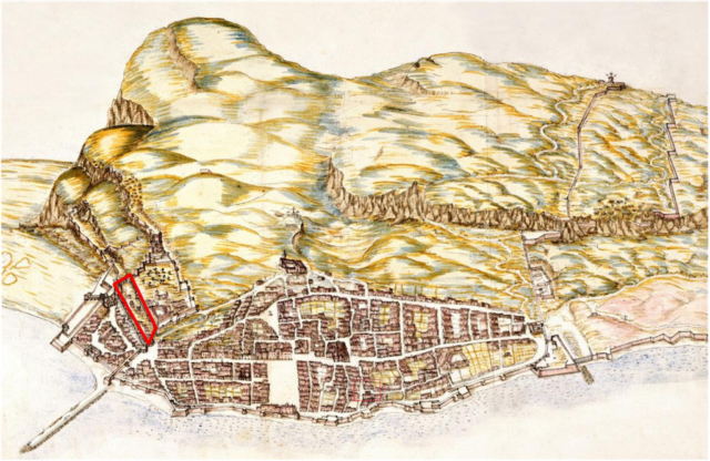
1627 Luis Bravo Plan – Villa Viaja area appears with limited structures with main populated area in the Turba to the south.
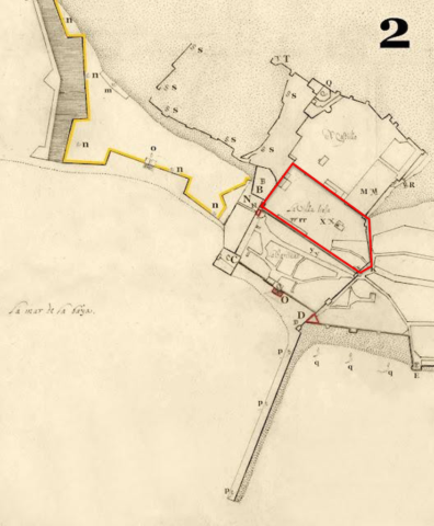
1669 - Menni's Map of Gibraltar - Section 2
Villa Vieja appears largely undeveloped with some possible structures on its southwest corner
Above: 1608 - Old Mole area ( Detail from map - Cristóbal de Rojas ) Below: 1567 - Anton van den Wyngaerde
No visible structures in either of these maps.
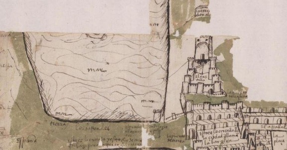
1540 - The Oldest Plan of Gibraltar - Botas de Vino as presented in Neville Chipulina’s website.
No visible structures within the area of the Villa Vieja.
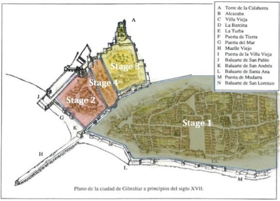
A Four-Phase Urban Development
Rather than seeing Villa Vieja as the origin of Gibraltar’s settlement, a more likely urban
sequence is as follows:
1. Stage 1 – Cathedral Precinct (La Turba)
The area around the Cathedral likely formed the initial civic centre, possibly even before Islamic times. Its flatter terrain, proximity to springs, and central location support this view.
2. Stage 2 – Barcina Enclosure
As the town grew, an expansion known as the Barcina was constructed. This northern zone would have enclosed any existing structures important for shipbuilding and trade. Historical events—like the 14th-century razing of Algeciras—may have prompted defensive works here and the construction of the atarazna. It also served to further protect the town from attack from the north.
3. Stage 3 – Castle Precinct
The Moorish Castle above likely served a multiple of uses including that as a military command post. While older than the Barcina in structure, its isolated and defensive nature makes it less likely to have housed the urban population. It was probably reinforced in response to external threats and the razing of Algeciras may have also acted as a catalyst for its upgrading.
4. Stage 4 – Villa Vieja Connector
The Villa Vieja may have emerged as a corridor linking the castle to the Landport Gate and the Barcina. Enclosed by walls and gates, protected staircases would have offered secure passage between military and civic zones and likely functioned as a containment area should the Northern defences be breached.
What the Chroniclers Say
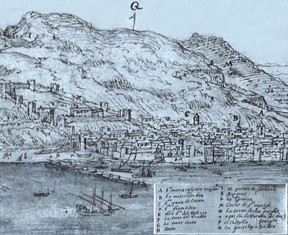
This view is further supported by Gibraltar’s earliest chroniclers. Alonso Hernández del Portillo, writing in the early 17th century, makes no reference to Villa Vieja as a main residential quarter. Instead, he focuses on la Turba and la Barcina, describing them as the town’s most populous areas. He also emphasises Puerta de Tierra—Landport Gate —as the principal land entrance.
Ignacio López de Ayala, writing in the 18th century, echoes these views. He writes that the town “was made up of two main districts: one called la Turba, and the other la Barcina.” Of Villa Vieja, he remarks that the name “does not appear to reflect its reality”—a subtle but telling comment that suggests the area lacked the function its title implies.
These firsthand accounts lend strong support to the idea that Gibraltar’s urban life was concentrated away from Villa Vieja, and that the name reflects a Christian-era classification rather than true antiquity.
Ayala
Why This Matters
Revising our understanding of Gibraltar’s earliest urban development isn’t just a matter of historical curiosity. It affects how we conserve, interpret, and present the town’s heritage— whether in tourism, education, or planning policy.
If the Cathedral and Parliament House precinct was the true urban core, then its street pattern, archaeological layers, and built fabric deserve even more attention. It also raises the possibility of further historical layers beneath today’s familiar buildings.
Meanwhile, Villa Vieja should be appreciated not as the cradle of the town, but as an important defensive and transitional space—one that speaks to the complex evolution of Gibraltar’s fortified urban structure over time.
Conclusion
As new research sheds light on old assumptions, it becomes clear that Gibraltar’s past is richer and more layered than its street names suggest. The Villa Vieja, far from being the original urban core, was likely a later development—strategic, enclosed, and militarily important, but not the birthplace of the town. Instead, the area around Parliament House, John Macintosh Square and Main Street
stands out as Gibraltar’s true urban origin, deserving recognition as the historic heart of the city.
Most Read
Government considers ‘life changing’ UK boarding school places for some children in care
Fri 10th Jul, 2026
Spain completes Gibraltar’s ‘long overdue’ removal from tax haven blacklist
Sat 27th Jun, 2026

Today's Paper
10th November 2025
Read our latest newspaper by downloading our app from the link below.

