


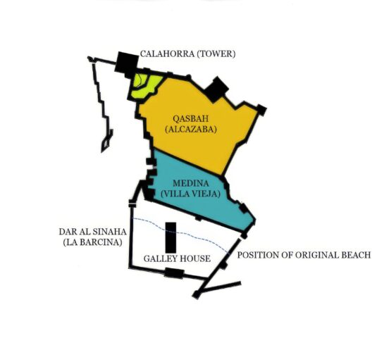
Casemates Square and Gibraltar’s Old Town – Part Two


In the fourth instalment in a series exploring the origins of the city and fortress of Gibraltar, Professor Clive Finlayson, Director of the Gibraltar National Museum, traces the history of Casemates and the Old Town.
Recalling how I ended the first part of my article on Casemates, I wrote how the eastern third of the atarazana wall, the part nearest the Rock, was completely different from the rest of the structure. Instead of big limestone blocks, it had been built from smaller stones held together with lime‑and‑sand mortar. I ended with a question - what was going on here?
The answer came from the sand beneath our feet. On the Rock side, the sand was clearly beach sand. At about a metre and a half below today’s surface, we were literally standing on Gibraltar’s old western shoreline. But to the west of the wall, the sand was much siltier and showed signs of having been underwater for long stretches. The conclusion was unavoidable: the medieval beach reached more than halfway into what is now Casemates Square, not down by the old Water Gate as many had assumed.
The big limestone pillars had been built to withstand the tides—they were sunk straight into the old seabed. A channel would have been dredged so that ships could be brought right into the atarazana through its own gate. Portillo (1610-1622) describes how galleys once entered the atarazana through a gate near the Water Gate, which in his time had already been sealed. In earlier centuries, the sea flowed straight through that gate into the building opposite. The gaps between the pillars would have allowed the tide to move freely in and out.
At some later point — probably soon after the atarazana’s construction — the western defensive wall was built to protect both the ships and the atarazana, as described in my previous article. It is clear that no sea wall existed in 1333. When the Merinids captured Gibraltar, King Alfonso XI besieged the place shortly after, setting up one camp above the castle and another on the red sands. He had no difficulty landing on the shore. Later in that siege, when catapults failed to damage the galleys inside the atarazana, he ordered Admiral Alfonso Jofre to burn them. But the Christian ships could not get close because the Merinids had thrown up a barricade. This improvised defence—built because there was no proper wall—likely convinced Abu Malik to advise his father Abu al-Hasan to construct a strong line wall soon afterwards. Two gates were opened in it: the Water Gate, and the Gate of the Atarazana for the galleys.
The atarazana was the earliest structure we uncovered anywhere in Casemates Square. Just to the east of its end—and at a deeper, older level—we also found traces of a slipway made with traditional mortar, right where the shoreline would once have been. That suggested that some kind of simple boat‑hauling facility existed here before the atarazana was built, perhaps in the time of Fernando IV or even earlier, during the Muwahiddun (Almohad) period in the twelfth and thirteenth centuries.
When we began digging, something did not add up, and we couldn’t solve the mystery until we worked out where the medieval coastline had actually been. In the area between that old shoreline and the Water Gate, we found many houses. The oldest ceramics from those houses dated to late fifteenth and sixteenth‑century Spain. But below those levels—where we expected earlier material—we found nothing but clean sand mixed with marine remains, especially oysters. No buildings, no rubbish, no occupation at all.
The explanation turned out to be simple. In Merinid times, this whole area was tidal. No one could have built houses there. Only later—once the intertidal zone had been reclaimed, or a stronger sea wall built, or perhaps once the channels silted up because they were no longer dredged—did the land become stable enough for houses. That seems to have happened in Spanish times, after 1462. This is a clear example of the need for caution when interpreting plans. Bravo’s plan of 1627 shows houses in this location but, had we interpreted that they had been there since the fourteenth century, we would have been wrong. The archaeology told us something else. On the landward side of the old beach, however, there must always have been a few buildings linked to the atarazana, and in that area we did find plenty of pre‑Spanish material.
Even in the late sixteenth and early seventeenth centuries, the tidal problem was still serious. The sea sometimes flooded the houses in Casemates, entering through the Atarazana Gate until that gate was sealed and the old mole was built at the end of the sixteenth century. Today the sea feels very far away from this part of town, yet during our excavation we could not dig deeper than about a metre and a half anywhere in Casemates because the tide seeped in twice a day!
The shift from a working port area to a residential one must have been driven by changes in ship design. The atarazana was perfect for the smaller Muslim sailing vessels, but it became obsolete once larger galleons came into use. By the time Bravo drew his plan, the building stood on dry land and probably served as a storehouse—perhaps for grain—though its exact use is not recorded. Once the shoreline had moved outward, people could start building houses in what must have been, despite occasional flooding, a relatively open and pleasant area.
Near the atarazana—sometimes even touching its walls—we found the remains of many houses with wells, along with bones from domestic animals: goats and sheep in particular, but also cattle, horses, and donkeys. One especially intriguing detail from the sixteenth‑century layers was the presence of very large oysters. The oyster-eating tradition lasted into the British period.
Poole, visiting Gibraltar in 1748, wrote that a local resident invited him to try the oysters, which were considered a speciality—and he too commented on their impressive size. They were still popular in the middle of the nineteenth century, when Edward Kelaart, botanist and medical officer of the garrison, who arrived in Gibraltar in 1843 and published his Botany & Topography of Gibraltar in 1856. Kelaart noted…
“On the left is the bay, which at this part has extensive oyster-beds, reserved for the Gibraltar market.”
Returning to the sequence of layers at Casemates: much of the ground above the houses of La Barcina was paved with irregular stones that had clearly been smoothed by the sea. This surface belonged to the eighteenth century and probably dated to the levelling of the square in 1731. We also found plenty of evidence of fires, which we linked to the eighteenth‑century sieges. In one spot we uncovered a large portion of a musket, including part of the wooden butt. The metal had melted and warped—proof of the extreme heat it had been exposed to. We also found many musket balls, larger shot, and fragments of clay pipes.
During this period the atarazana was being used as a Shot House, as shown in the 1753 plan. The spaces between the pillars had been filled with a different mortar, presumably to isolate the ammunition stored inside. When the British took Gibraltar, they must have reused whatever solid buildings they found, and a structure with thick stone walls like this one would have been ideal. It remained important enough that it continued in use even after the damage of the 1727 siege. It was only after the Great Siege of 1779–83 that it seems to have been abandoned—either because it was badly damaged or because it was no longer wise to keep ammunition so close to enemy fire. Its final disappearance came with the construction of the Casemates Barracks in the early nineteenth century. For nearly two hundred years it lay buried beneath the feet of marching soldiers and, later, the wheels of cars—until we uncovered it again in 1998.
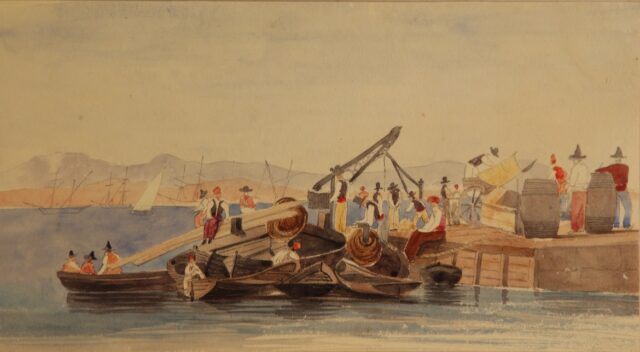
During the calmer nineteenth century, Gibraltar developed into a lively trading port. Old photographs from the mid‑ and late‑1800s show Waterport buzzing with commercial activity. We saw the archaeological evidence of this in the upper layers of our excavation: a remarkable variety of ceramics, including fine china, Italian wares, and pieces from different parts of Spain such as Triana (Seville) and Talavera.
By the time the Belgian artist Anton van den Wyngaerde sketched this part of Gibraltar in 1567, the walls had already been heavily reinforced. His sketches bear no relationship to what the place had been like over two centuries earlier. The Spaniards no longer needed the atarazana, so they reclaimed the old tidal zone and built houses on it. When the British arrived in the eighteenth century, the area changed purpose yet again. What had once been a port, and later a residential neighbourhood, became a military zone. Most of the remaining houses were demolished soon after the 1727 siege.
The atarazana itself reached the end of its life when the Shot House was destroyed or pulled down. But the construction of the Casemates Barracks ensured that the area’s military role continued well into the nineteenth—and even the twentieth—century.
Most Read
RGP records 582 domestic incidents, with women disproportionally affected
Mon 9th Mar, 2026
Notifying Spain over residency permits offers ‘additional layer of protection’
Thu 26th Feb, 2026

Today's Paper
9th March 2026
Read our latest newspaper by downloading our app from the link below.

