


Border through the ages: How the frontier came to be
Frontier with Spain, the Spanish customs post, c1910.


By Richard Garcia
We have always known the frontier between Gibraltar and Spain in its present location. We have also always heard the Spanish position that there are two disputes over Gibraltar, one in relation to the Spanish claim over the territory of Gibraltar (as defined by Spain) that was ceded to the British Crown in perpetuity under the Treaty of Utrecht of 1713; and one in relation to the Spanish claim over the isthmus, from the North Face of the Rock up to the present frontier fence. But what is the true status of the isthmus? Who decided where the frontier line between Spain and Gibraltar would be drawn, and when?
The first place to look is of course Article 10 of the Treaty of Utrecht between Britain and Spain of 13 July 1713 (This was one of a number of treaties which were agreed at Utrecht in 1713).
All that the Article set out was that Britain was to enjoy “the full and entire propriety of the town and castle of Gibraltar, together with the port, fortifications, and forts thereunto belonging,” and that it was “to be held and enjoyed [by Great Britain] absolutely with all manner of right for ever, without any exception or impediment whatsoever”.
The “propriety” or ownership of Gibraltar was therefore clearly ceded by Spain. Gibraltar was being treated as simply a possession or a chattel that could be owned by an individual, the King of Great Britain, who could then dispose of it at will (subject to any conditions attached in the wording of the Treaty).
The grant was “for ever”, which puts paid to any assertion by Spain that there is a dispute over Gibraltar. There is no dispute between Britain and Spain over Gibraltar: there is simply a Spanish claim over the territory of Gibraltar. The grant was also “without any… impediment whatsoever”, a clause that Spain failed to honour time and time again.
Unhelpfully, there is nothing in Article 10 of this Treaty that precisely defines the territory of Gibraltar and more specifically where the outermost limit of Gibraltar was at the time that the treaty was signed.
It is essential to consider the geopolitical reality at the time of the Treaties of Utrecht of 1713. There was then no La Linea. Algeciras was mainly a heap of ruins of the former Moorish city, and had long ceased to be the important place it had been in the 14th century. The rebuilding of the town had only just commenced. Some of the Spanish inhabitants who left Gibraltar in 1704 had established a small settlement in the vicinity of the hermitage of San Roque, and this was later to grow and become the city of San Roque. It was at an early stage of its development. What was later to become the town of Los Barrios had only just been founded.
There was therefore no settlement of any significance in Spain close to Gibraltar in 1713, and there was nothing at all where La Linea stands today. The nearest building to Gibraltar was the Cuartel de Tessé, a barrack-block, at Punta Mala at the entrance to what is today the municipal district of San Roque at Campamento. It was situated to the west of the Arroyo del Cachón de Jimena, the stream that forms La Linea’s western boundary. Indeed, the town that later developed at Campamento took its name from the military encampment.
The Treaty of Utrecht of 13 July 1713 refers specifically to Gibraltar’s castle, fortifications and forts. There can be no arguments as to what comprised the castle of Gibraltar. This had nevertheless to include the Outer Castle stretching down to Casemates Square, as well as the Inner Castle and the Tower of Homage.
The definition of “fortifications and forts” is a little more challenging because of the position adopted by Spain after the event. What exactly were they?
Given the absence of any Spanish fortifications in the vicinity of the city of Gibraltar in 1704 (when Gibraltar was taken), other than Gibraltar’s fortifications, it is logical to assume that all fortifications close to Gibraltar must have been and needed to be considered as Gibraltar’s fortifications. If they were not Gibraltar’s fortifications, whose were they?
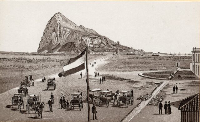
Prior to August 1704, the nearest towns to Gibraltar were Jimena and Tarifa. Gibraltar’s fortifications therefore necessarily included the Devil’s Tower, which stood at a short distance north of the North Face of the Rock of Gibraltar, close to Eastern Beach, in the area of the roundabout leading to Kingsway. The defences also necessarily included a round tower and mill that stood close to the shore of the Bay of Gibraltar in the area of Western Beach, at a distance of some 600 metres from the North Face of the Rock. These towers were the outposts of Gibraltar’s landward-facing defences.
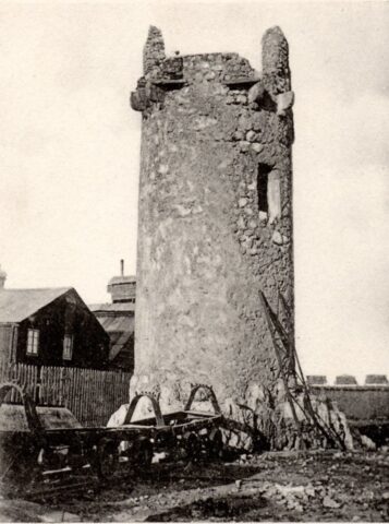
They had to be included in the territory ceded to Britain by Spain. Devil’s Tower was within musket shot of Gibraltar, and the round tower next to the Bay was within cannon-shot of Gibraltar and, more so, of its port. It is inconceivable that Gibraltar could be ceded by Spain to Britain, to enjoy in the manner specifically set out in the Treaty of Utrecht of 13 July 1704, namely with all manner of right and without impediments of any sort.
None of this, of course, prevented Spain from arguing from an early date after Gibraltar was taken, and both before and after the Treaty of Utrecht, that the Devil’s Tower and the round tower by the Bay were Spanish and that they were not fortifications. The assertions were rebuffed on every occasion by the Governor or commandant of Gibraltar and the British government. Indeed, the very fact that they were defensible positions, and that they were close to Gibraltar, strengthens the arguments in favour of their being included in the “fortifications and forts” of Gibraltar.
It should not be forgotten that it was standard practice in the early 18th century to consider that the land and sea within range of the guns of a city belonged to that city. This did not have to be spelled out because it was accepted by everyone. Indeed, a Spanish military report of 1888 stated that, in the early 18th century, the jurisdiction of a fortress included all the territory within range of its guns. The report, as is to be expected from a Spanish document, then set out that the general rule did not apply in the case of Gibraltar because the Treaty of Utrecht of 13 July 1713 was silent on this point. This view studiously ignores the fact that it was unnecessary to spell out in the Treaty what was generally accepted by all sides as the basis for establishing jurisdiction and control.
The Devil’s Tower and the mill tower next to the Bay of Gibraltar were first occupied by the British garrison at Gibraltar shortly after the capture of Gibraltar and before the Treaty of Utrecht of 13 July 1713. Indeed, in May 1709, stores for their defence and a signal cannon were placed in each of them. Guards from the fortress of Gibraltar were mounted there. Later, in November 1713, the advice of the Chief Engineer to Lieutenant-Governor Congreve in Gibraltar was that both towers were essential for the proper defence of Gibraltar.
The land on which these fortifications stood was therefore deemed in practice by the British to be part of the territory that was formally ceded to Great Britain under Article 10 of the Treaty of Utrecht of 13 July 1713.
This already calls into the question the Spanish assertion that none of the isthmus to the north of the North Face of Gibraltar was ceded. The only argument adduced by Spain is that the isthmus was not mentioned in this particular Article of the Treaty of Utrecht, and that the limits of Gibraltar therefore ended at the northernmost walls of the city. This reasoning has been questioned above, because the language of the Treaty specifically refers to Gibraltar’s forts and fortifications and they were specifically and unambiguously ceded by Spain to Britain, and they necessarily included those on the isthmus. Over and above that, was the convention that territory within range of its guns belonged to that territory.
In the immediate post-Utrecht years, the initial Spanish reaction was to challenge the occupation by Congreve of these fortifications on the isthmus, again arguing that they were not fortifications at all.
Don Andrés Pérez, the Spanish commandant in the hinterland, complained that Gibraltar’s occupation of these towers was a violation of Article 10 of the Treaty of Utrecht of 13 July 1713. Congreve did not agree. The stance adopted by Congreve was strongly supported by London, and Lord Bolingbroke wrote to the British Ambassador in Madrid to represent that it was unreasonable on the part of Spain to ask that these defensive positions should be relinquished by Britain as they were essential to the defence of Gibraltar, which might otherwise at any time be the object of a surprise attack.
Spain was upset that these defence works and the land on which they stood were no longer under Spanish control and continued to insist they were not British and that they encouraged smuggling of contraband into Spain, thereby contravening the Treaty of Utrecht. Management and control of part of the isthmus by Gibraltar was reinforced between 1720 and 1723 when three large vegetable gardens and orchards, to supply the needs of the Gibraltar garrison and the civilian inhabitants, were planted in the vicinity of the Mill tower. Civilian residents of Gibraltar managed these gardens. Cattle from Gibraltar were also grazed on the isthmus. Gibraltar was therefore enjoying, from a very early date, the sole use of a part of the isthmus.
Once again, Spain protested and the reply from the British Ambassador in Madrid, William Stanhope, to the Spanish government in August 1723 was clear and unequivocal. Stanhope set out that it was “unquestionable” that when a town was ceded, there was also tacitly ceded all the adjacent land that was commanded by its artillery as otherwise it was not possible to enjoy safe possession of the place that had been ceded.
Four years later, in 1727, Spain besieged Gibraltar. One of the reasons given by Spain for declaring war against Britain over Gibraltar was that she considered that Britain had pushed out its frontier to the north of Gibraltar and encroached into Spanish territory. Spain then seized possession of the Mill tower and the Devil’s Tower on the isthmus, and the Spanish front line was then less than 400m from the North Face of the Rock. The siege, however, was short-lived.
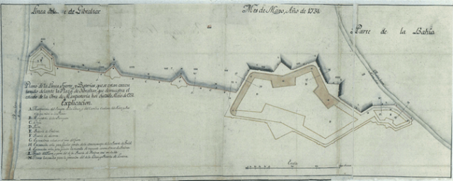
Afterwards, Spanish troops were withdrawn. It was then decided by Spain in 1728 to define in a clear way where Spanish territory began. It was the first clear demarcation of a frontier, and it was Spain who drew the line. It was not the subject of negotiation and discussion with the British military in Gibraltar: it was a unilateral act, on the part of Spain. It took some time for arrangements to be completed and for the Spanish guards to be withdrawn from the Devil’s Tower and the Mill tower, back to the new frontier line.
From a geopolitical perspective, the logical point to draw this line indicating where Spanish territory commenced was of course at the head of the isthmus. This, indeed, is where Spain built two forts, that of Santa Barbara on the Mediterranean side and the much larger fort of San Felipe on the Bay of Gibraltar side, and they were linked by a wall. This line became known in due course as “la línea”, and the town that eventually grew up behind it was named La Línea de la Concepción.
Persons leaving Gibraltar and entering Spain on and after the building of the line of defence, were checked at “la línea”, where there was a gate known as “el rastrillo”. It was not the case that they were checked by the military or by customs at the mid-point between the North Face of Gibraltar and the Spanish line. Persons leaving Spain in the direction of Gibraltar had to pass by the British sentries who patrolled the area on the isthmus immediately to the north of the site of the Mill Tower.
Spain could have erected the forts and the wall linking them at the mid-point of the isthmus. This is what she would have done if she had felt that the gap that needed to be allowed between the Spanish frontier line of defence and the British line of defence was the distance of a cannon-shot. The fact that Spain chose to build its frontier line at a distance in excess of a cannon-shot suggests that she was tacitly accepting the British assertion that the land ceded to Britain under the Treaty of Utrecht included the land on which the outermost fortifications – the Devil’s Tower and the Mill Tower – were situated, and that this land was rightfully occupied by Gibraltar.
Indeed, in the build-up to the Treaty of Utrecht of 13 July 1713, the British stated to the French (who were initially negotiating the wording of the Treaty on behalf of Spain) that Britain claimed “an extent of country round Gibraltar equal to two cannon shot”. This claim was hotly rejected by Spain at the time. However, the fact that Spain built its line – “la línea” – at a distance equal to two cannon shot shows an eventual silent recognition by Spain of the British position.
There is one further aspect that needs to be considered in detail. The port of Gibraltar was explicitly ceded by Spain to Great Britain. However, once again, the limits of the port were not defined in the Treaty of Utrecht of 13 July 1713.
The fact that the port of Gibraltar is today situated to the immediate west of the city of Gibraltar does not mean that this was the port in 1713. It was not. The waters that are today port waters would not have enjoyed any shelter from the south-westerly winds or strong easterly winds prior to the building of the north, detached and south moles in the 1890s and early years of the 20th century. The most sheltered waters were at the head of the Bay of Gibraltar to the north of the area where the westerly runway is situated today. This was the anchorage of the port of Gibraltar at the time of the Treaty of Utrecht.
We know this because this area of sea was described as Gibraltar’s “proper anchorage” by an old inhabitant, Juan De La Rosa, who included this in a sworn deposition he wrote in 1766 when he was an old man. Britain indeed protested that the siting of guns in the Fuerte de San Felipe rendered Gibraltar’s anchorage useless, as vessels there were within range of the Spanish guns. De La Rosa’s description of the area of sea to the north of Gibraltar as the “proper anchorage” is reinforced by the Spanish decision to build their line of defence, and the Fuerte de San Felipe, beyond the limit of Gibraltar’s port waters. To have built the fort on the shore of waters that constituted a part of Gibraltar’s port would have created a further row between Britain and Spain.
So, it is clear from the Treaty of Utrecht of 13 July 1713 that no definition of precisely what constituted the city and port of Gibraltar was included in the Treaty; Spain adopted the view from a very early date that the land ceded by Spain ceased at the North Face of the Rock of Gibraltar and did not include the isthmus; and Britain maintained from the outset that in order to enjoy ownership of Gibraltar, the territory of Gibraltar had to include the defences on the isthmus and the land on the isthmus within range of Gibraltar’s guns, in accordance with the standard international conventions of the day. It is also equally clear that Gibraltar used part of the land on the isthmus, the half closest to the North Face, for non-military purposes, establishing market gardens for Gibraltar there. The area was patrolled by British sentries, in the same way that some Spanish sentries patrolled in the area immediately to the south of the defensive line, “la línea” and to the north of the line of British sentries. Britain has enjoyed sole jurisdiction, occupation and control over the southern half of the isthmus for over 300 years.
From 1704 and right up to the closure of the frontier in 1969, there was no Spanish exploitation of the land in what eventually became known as the Spanish Neutral Ground.
The most telling fact is that Spain, of its own motion, defined in the early 1730s the line where Spanish territory began and fortified it with a wall and two powerful forts, and that it was sited in compliance with the British demand that the land up to two cannon shot belonged to British Gibraltar. Of course, Spain continued the rhetoric in support of its view that the neutral ground had been usurped by Britain, but it was not to be expected that they would openly and publicly accept the British position. It would have been a climbdown and would have offended their pride.
Much later, in 1908, the British began to erect an unclimbable frontier fence to define what was then deemed to be the outer limit of Gibraltar. It was situated where the frontier fence is today. It was the first frontier fence. Spain never built a frontier fence of its own. By this time, Britain did not claim all the territory between the North Face of Gibraltar and the line defined by Spain in the 1730s to indicate where Spain began. It only claimed half of the territory. When the works to build the frontier fence were about to begin, Britain informed Spain, not because she considered that there was an obligation to do so, but out of courtesy. Six months after they were so informed, Spain reacted and objected to the fence. The objections then fell silent when Britain said that the fence would help prevent illegal smuggling from Gibraltar to Spain.
Much later, a Spanish police post was sited at the mid-point of the isthmus, adjacent to the British police post. This followed the changes introduced by General Franco after the Spanish Civil War, when Gibraltarians were first required to have a passport or other official document in order to cross into Spain from Gibraltar. Eventually, Spain decided that it was useful that there should be a frontier between Spain and Gibraltar, even though she refused to recognise it as an international frontier and referred to it simply as “a fence”. It must be the only fence in the world for which a passport or internationally recognised travel document was required of anyone who wished to cross it.
Nevertheless, the presence of the frontier fence and frontier gates meant that Spain was able to close this border crossing in 1969, something which would have been impossible had there not been a frontier.
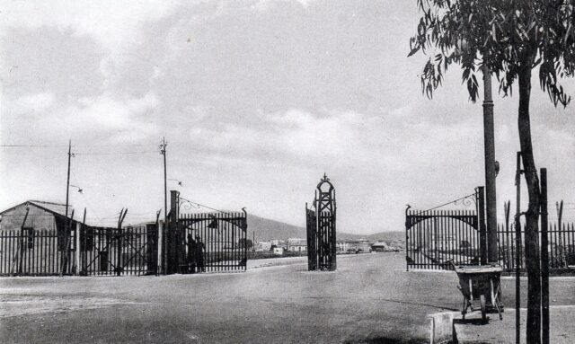
The Spanish customs post, up to 1969, remained in the same location that had been established in the early 1730s. In the first seven decades of the 20th century, the land between the Gibraltar frontier and the Spanish customs post was known as the “Spanish Neutral Ground” or simply “the Neutral Ground”.
These arrangements are now, once again, going to change. Different arrangements are being ushered in at the land frontier between Gibraltar and Spain. They should be viewed as new steps that are being taken as part of a long historical process, stretching back to 1704. It is a process that has seen considerable change over the years – and which may yet see further change in the future.
Most Read
Rock’s digital security system sends warning beyond Gibraltar, Parliament told
Fri 16th Oct, 2026
New group to plan healthcare jobs and placements for returning graduates
Tue 13th Oct, 2026
Fourth Committee welcomes Gib treaty as UN approach to decolonisation faces US criticism
Fri 16th Oct, 2026

Today's Paper
15th July 2026
Read our latest newspaper by downloading our app from the link below.


