


Casemates Square and Gibraltar’s Old Town – Part One


In the third instalment in a series exploring the origins of the city and fortress of Gibraltar, Professor Clive Finlayson, Director of the Gibraltar National Museum, traces the history of the Old Town and Casemates Square.
In my first article in this series, I wrote about the first settlement to have been built on the Rock, in 1160. Given the ease with which Gibraltar had, later on, been taken by the Castilians under King Fernando IV in 1309, I argued that the large city and fortress which had been planned in 1160 never reached its projected dimensions. Historical references backed this view up. In 1309, shortly after his troops had captured Gibraltar, King Fernando IV rode into town and ordered the walls—knocked down by the siege engines—to be rebuilt. He also commanded that a new keep [torre] be put up (Cronica de Fernando IV, ca 1340):
“to be built above the slope of the town, and also a dockyard [atarazana] between the town and the sea so that the galleys should be safe.”
This passage tells us that a tower was to be built on the slope above the town. This spot is where the first tower, ordered by King Fernando IV, stood. The thick outer walls of this early tower still survive today, now enclosed within the present tower of the castle. The large tower that we see today was erected later, by the Merinid Muslims after the earlier tower had been damaged by the attacks by the Merinids themselves during their assault in 1333 and, shortly after, by the Castilian forces of King Alfonso XI when they attempted to retake Gibraltar soon after its fall, also in 1333.
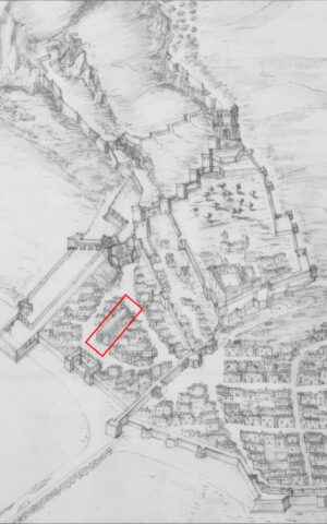
Importantly, we have a first-hand account from 1309 that tells us that clearly that the atarazana was to be situated between the town and the sea. In other words, the town was located in the area currently above Casemates (the atarazana) and below the tower: the area occupied today by the Road to the Lines, Crutchett’s Ramp and possibly the Moorish Castle Estate. This area was known in Spanish times as the Villa Vieja (old town), it seems for good reason. The area of the Moorish Castle Estate became the Qasbah, the traditional fortified residence of the governor or emir, after 1333, and may have existed in some form prior to this. The Villa Vieja, next to and below the Qasbah, fits naturally into what would have been the Medina (or Old City, that is Villa Vieja), with its dense network of narrow alleys.
We already had a good understanding of the area of Casemates when, early in 1998, we were finally given the chance to excavate part of Casemates Square. It was the first time in our short experience with urban digs that we were allowed to work before a construction project began, which meant we could take our time without pressure from developers. The earliest plans that we had available of Gibraltar were those drawn by Luis Bravo Acuña in 1627. Bravo was an engineer who was concerned with the repair and strengthening of the fortifications of Gibraltar.
The originals are in the British Museum in London. The significance of these plans is that they pre-date the sieges to which Gibraltar was subjected in the 18th Century, and which destroyed much of its urban fabric, and the consequent and subsequent major modifications to the fortress done by the British in the 18th and 19th centuries. Even though the Spaniards had made changes to the fortifications after 1462, the basic layout of Gibraltar had changed little since Abu l-Hasan’s expansion after 1333 (my previous article) so that Bravo’s plans are especially useful in helping us understand, with due care accounting for the passage of some three centuries (1333-1627), the structures that we uncover under the present City of Gibraltar.
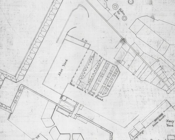
Using Bravo’s old plans and, above all, a detailed 1753 British map of the square, we chose a spot at the northern end, close to the Casemates Barracks built in 1817, for excavation. Bravo’s plan showed a long, arched building in this part of the square, but we had no idea what it was. The 1753 map also showed a long structure in the same spot, labelled the Shot House, and it included a row of square blocks running along the outside walls. Several eighteenth‑century writers mentioned this Shot House and also talked about a medieval atarazana in the square—but of course they were writing over four hundred years later so we could not ascertain the veracity of the claims.
Still, we formed a hypothesis: the Shot House either was the old atarazana or stood directly on its site. Since we had already worked out the position of the Gate of the Barcina the previous year, we used the plans to calculate where the southern wall of the Shot House should be. Then we began to dig…
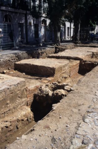
When you first start digging, you often uncover bits of structures that make no sense at all, which is why you have to move slowly and carefully. It’s only after you’ve opened up a large enough area that the pieces begin to connect and you can finally understand what you are looking at. I still remember the first stretch of wall that we found on this excavation: at the beginning we could not even tell which direction it ran until we exposed more of it. It felt like wiping a tiny clean patch on a dirty window—only when you clean more of the glass does the full view start to appear. That wall turned out to be the southern side of the atarazana, and our earlier estimates—based on intuition and the accuracy of the 1753 plan—were off by just one metre!
So, what did we actually find? The excavation at Casemates allowed us to trace how the square had been used from its earliest days right up to the present. The most important discovery was the south wall of the atarazana. The construction style and the ceramics found alongside were typically Merinid (from the reign of Abu l-Hasan), with a few Nasrid (from the kingdom of Granada) pieces showing that Gibraltar and Granada had been in contact.
During the first phase of the dig, from 20 April to 31 July, 1998, we uncovered most of this wall, but we couldn’t reach the western entrance. We arranged with the Government of Gibraltar to investigate that area once the developers opened it up. We finally got access between 24 and 28 May the following year—and on the very first day we found the entrance exactly where we had predicted. The whole building measured 40.8 metres long, almost the full width of today’s square, an impressive size for a medieval structure.
The wall we uncovered was the southern one; the northern wall had almost certainly been destroyed when the Casemates Barracks were built, and any trace of it now lies underneath that building. The wall we could study fell into two very different construction styles.
The western two‑thirds—the parts closest to the sea—were made up of massive limestone pillars, each about 2.5 metres wide and over a metre long. Between these pillars ran short stretches of low wall lined with brick. Based on what we know from other atarazanas and from Bravo’s drawings, this layout almost certainly supported a row of arches that once formed the roofed area of the building. The low sections between the pillars would have allowed workers to reach the sides of the ships, giving them more room to manoeuvre in what was otherwise a tight space.
The eastern third of the wall, the part nearest the Rock, was completely different. Instead of big limestone blocks, it was built from smaller stones—many of them sandstone—held together with the typical lime‑and‑sand mortar of the period. Where these two construction styles met, we found another Merinid wall running south at a right angle. So, what was going on here? I will answer this question in my next article.
Most Read
Gibraltar entrepreneur develops eco-friendly paddleboards with an eye on sustainability
Thu 9th Apr, 2026
Commission mulls Spanish proposal for EES flexibility at border
Thu 9th Apr, 2026

Today's Paper
23rd February 2026
Read our latest newspaper by downloading our app from the link below.

